
Using satellite imagery in conflict-affected areas in Mali to support WFP’s emergency response
By Laure Boudinaud, Nanthilde Kamara and Amadou Ibrahim
Laure Boudinaud is a geospatial analyst for the World Food Programme (WFP), applying remote sensing techniques and analysis in West and Central Africa. Previously, Laure worked at WFP HQ and at the European Space Agency’s Centre for Earth Observation.
Nanthilde Kamara is the Emergency Preparedness and Response Officer with the WFP in the Mali Country Office. She has 16 years’ experience working in the humanitarian sector for various agencies at field and HQ level in food security, livelihoods and nutrition.
Amadou Ibrahim is a Senior Programme Assistant at the WFP Mali Country Office with over 15 years of professional experience in the field of Geographic Information System (GIS), mapping and remote sensing.
The authors would like to thank all those who contributed to this work, specifically the World Food Programme Vulnerability Analysis and Mapping (VAM) teams in the Mali Country Office and in the Regional Bureau of West and Central Africa. We would also like to thank partners at the National Early Warning System, the Ministry of Agriculture in Mali and community members in the Mopti region who kindly participated in this analysis. We are grateful to the UK Foreign, Commonwealth & Development Office (FCDO)1 who funded this initiative.
Location: Central Mali
What we know: In conflict-affected areas, it is often challenging to obtain near real-time information on crop changes to estimate future food insecurity levels.
What this article adds:
A pilot study was carried out by the World Food Programme (WFP) Mali in the Mopti region in 2019 where earth observation data was used to detect cropland abandonment in hard-to-reach areas to assess the physical impacts of conflict on croplands and therefore detect populations in likely need of food assistance. Compared to pre-conflict years (2016 and 2017), 25% of localities in the region experienced a decrease in cultivated lands. Findings were triangulated with population and contextual data including available information on insecurity and local armed conflicts, agricultural season evaluations, displacement estimates and satellite images assessing damage to villages. The results were also validated through field interviews with villagers. The added value of this analysis included a strengthened early warning for prompt action (used during the Cadre Harmonise survey and by the Food Security Cluster and the World Food Programme to prioritise localities for response) and evidenced advocacy to partners and donors. The interpretation of satellite imagery does not replace field surveys; triangulation with official datasets and other data sources is essential. Strengthened technical capacities and early engagement with local ministries and partners is necessary for buy-in and acceptance.
Background
In 2019, the security situation in the region of Mopti, central Mali, deteriorated dramatically. High rates of violence were triggered by the presence of armed groups and self-defence militias, increasing criminality and inter-communal tensions. Such rising levels of insecurity led to approximately 1,300 fatalities and tens of thousands of internally displaced people across the region. Given the already fragile nature of the context, due to mounting demographic pressures, high rates of youth unemployment, soil degradation, scarcity of natural resources and repeated droughts, this quickly spiralled into a food insecure situation. Agricultural activities in Mopti were immediately heavily curtailed due to the restriction of physical access to fields imposed by armed actors and the displacement of entire communities. Fields that were previously cultivated before the security crisis were abandoned for fear of violence in a number of localities, with differing degrees of loss. Additionally, the impact of insecurity and violence led to entire communities being confined to their villages, unable to access markets, cultivate distant fields or reach neighbouring localities. For those populations forced to abandon distant agricultural fields and adapt their farming practices to the security context, the harvest was insufficient to feed the community until the following harvest season in September/ October 2020. In both cases, displaced or confined, populations relied almost entirely on humanitarian assistance and needed to be prioritised for food assistance and livelihoods support.
This article presents a pilot study during which the World Food Programme (WFP) Mali used European Space Agency’s Centre for Earth Observation data to detect cropland abandonment in hard-to-reach areas as a means of assessing the physical impact of the conflict on cropland areas and therefore detecting those populations in likely need of food assistance.
Methodology
For each year between 2016 and 2019, Sentinel-2 images (provided by the European Space Agency2) were acquired, processed and analysed in order to detect cropland change by locality in the Mopti region. The analysis consisted of creating a composite of maximum normalised difference vegetation index (NDVI) images from three distinct periods within the growing season. The composite generated a Red-Green-Blue image where the red band represented the start of the growing season, the green the middle and the blue the end. The resulting image highlighted areas with temporal patterns of cropland which are different from natural vegetation, built-up areas or other land cover types. To provide a comprehensive overview of an area of interest, up-to-date granular data is essential. The satellite imagery used for this analysis (Sentinel-2) offers details at a 10-metre resolution, enabling results at village scale. A new image is captured every five to six days on any given point on Earth, guaranteeing homogeneous, frequent and updated data for the whole area of interest.
In theory, the period between June 15th and October 15th covers an agricultural cycle in the region of Mopti, from land preparation to the early stages of harvesting. Satellite images acquired during these four months were processed in order to identify cultivated land for each year from 2016 to 2019. A semi-automated method was developed for this study which involved several processing steps including automatically calculating and mapping the yearly composites derived from the maximum values of the vegetation index for the beginning, middle and end of the season followed by visual interpretation by a remote sensing expert to determine the type of change in vegetation seen between the year of interest and the reference year. This enabled approximatively 3,200 localities to be covered, measuring for each the degree of cropland change in the surrounding area between 2019 and a selected year prior to the conflict. Two reference years (2016 and 2017) were selected as two baselines are useful to account for possible cloud cover in one year which makes interpretation more difficult. Figure 1 provides an example of image comparisons conducted between 2017 and 2019. This analysis provided a meaningful interpretation of the data to explore patterns and identify vulnerability hotspots across the region. More details on the datasets and the processing steps are provided in the report, ‘Satellite Imagery in conflict-affected areas’.3
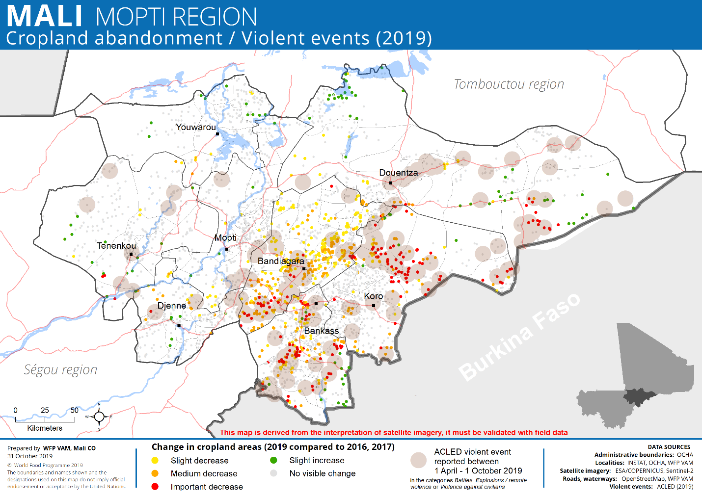
The map in Figure 2 depicts, in yellow, orange and red, the localities where slight, medium and severe cropland loss (respectively) was detected in 2019 compared to 2016 or 2017. Slight cropland lost was classified as <25% of cultivated surface area loss between 2019 and the selected reference year, medium cropland lost was classified as between 25%-50% of cultivated surface area loss and severe cropland loss was classified as >50% of cultivated surface area loss between 2019 and the reference year. Grey dots represent villages where no evident change was visible or where there was no agricultural land. Brown circles represent violent events reported by the Armed Conflict Location and Event Data Project (ACLED) between April and October 2019.
Figure 1: Satellite images showing the impact of movement restrictions on cropland patterns around three villages (Koro Cercle)
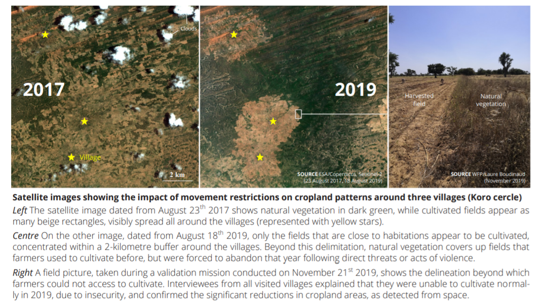
Figure 2: Cropland abandonment and violent events in Mopti Region, Mali, 2019
Main findings
This methodology enabled a regional-scale interpretation of the European Space Agency’s Centre for Earth Observation data, examining several landscape changes that can be detected from space including significant reductions in cropland areas, damaged and abandoned infrastructures and neatly demarcated cropland areas concentrated close to habitations. More specifically, Figure 2 shows that:
- No visible change was detected in the majority (72%) of the 3,166 localities analysed.
- In total, 25% of localities in the region of Mopti experienced a decrease in cultivated lands compared to pre-conflict years (2016, 2017).
- The cercles4 most affected by significant cropland diminutions are Koro, Bankass, Bandiagara and Douentza which are the areas where inter-communal tensions led to many acts of violence in 2019.
- No evident change was detected in most localities of the western cercles of the region with Youwarou, Mopti, Tenenkou and Djenne experiencing fewer cropland losses than the east of Mopti region.
- For a minority of localities (3%), croplands slightly increased in 2019 compared to pre-conflict years. This may be due to favourable climatic conditions despite a late start to the rainy season. Some of these localities were in hard-to-reach areas with the presence of non-state armed groups while others (for example in the west) were in relatively secure areas that experienced few attacks despite the presence of armed actors.
- Violent events between April and October 2019 (as documented by ACLED) overlapped with the analysis results, illustrating the correlation between insecurity and agricultural decline. Insecurity peaks in 2019 heavily affected agricultural activities in the eastern part of the Mopti region.
Triangulation with population data
In 2019, the region of Mopti had an estimated population size of three million people (Direction Nationale de la Population, Mali, 2019). To assess the possible impact of cropland losses in terms of population (rather than in numbers of localities), several credited population datasets that depict the distribution of the population were analysed. Specifically, the High-Resolution Population Density maps, which represent estimates of population counts per pixel at a 30-metre resolution, were selected to provide population estimates in areas affected by agricultural decline in the region. For each category of cropland change (slight, medium and severe cropland loss), the projected population estimated to live within a 2-kilometre radius around the sites was calculated (this was an approximation and did not take into account displacement as such data at locality level was unavailable). In total, 130,000 people were estimated to live in areas affected by severe cropland loss (4.3% of the total population), out of which 50,000 were in the cercle of Koro and 35,000 in Bankass. In addition to this, 215,000 people were estimated to be in areas affected by a moderate cropland loss (7.2%) and 260,000 by slight cropland loss (8.6%). Around 200,000 people were estimated to be benefiting from a slight cropland increase.
Triangulation with contextual data
Cropland abandonment, as visible from space, is one of the many consequences of the widespread violence in central Mali. Damaged infrastructure and abandoned villages were also spotted during the interpretation of the satellite imagery. To better understand how the findings correlated to the security context, datasets, such as those with geo-referenced violent events, field data, aggregated displacement data and agricultural seasonal evaluation reports, were analysed for cropland changes. The results were subsequently cross-checked with official agricultural evaluations.
Insecurity
In June 2019, when land preparation and planting were underway, a peak in both significant violent incidents and the number of fatalities was recorded in the region. Indeed, most of the significant cropland losses occurred in localities where violent events were reported between April and October 2019, as depicted in Figure 2. During that period, 190 of the 305 violent events reported for Mali occurred in the Mopti region, 90% of which were in the four eastern cercles of the region (Bandiagara, Bankass, Douentza and Koro). Due to the presence of multiple armed groups, inter-communal violence was exacerbated in those cercles and the general security context was highly volatile. In contrast, the cercles of Tenenkou, Mopti, Youwarou and Djenne recorded fewer violent events in the same period. These areas are in the west where, as noted previously, the presence of a non-state armed group is deeply rooted (a different context than in the east) and thus, while there was high criminality, there were no attacks which allowed for a relatively calm situation. This may in part explain a more typical pattern of agricultural activities in this region than in the east.
Agricultural season evaluation
The early warning system of the Malian food security commissary (Système d’Alerte Précoce) prepared a map (Figure 3) indicating the evaluation of the 2019-2020 agricultural season. It confirmed a ‘bad’ to a ‘very bad’ agricultural season (as classified through the Système d’Alerte Précoce) in most of Douentza Cercle (east), Koro Cercle (north), Bandiagara Cercle (south) and Bankass Cercle (south).
Figure 3: Evaluation of 2019-2020 agricultural campaign, Mali (February 2020)
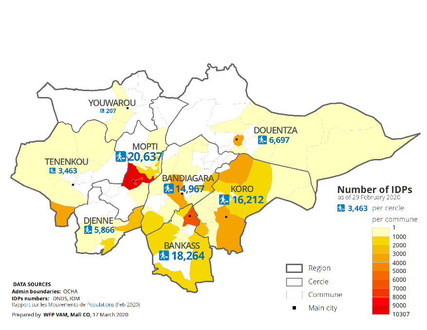
Displacement
As of February 2020, it was estimated that over 86,000 people were internally displaced (IDPs) in the Mopti region, approximatively 40% of the total population of IDPs in Mali.5 Figure 4 indicates the number of IDPs per cercle and per commune as of 29 February 2020. The majority were located in the three cercles most affected by violent events and cropland changes (Koro, Bankass and Bandiagara) as well as Mopti Cercle. Many IDPs sought to reach major towns where the security situation tended to be safer. Around 18,000 IDPs were estimated to be in the Mopti and Socoura communes where Mopti town and Sévaré are located. The communes of Bankass, Bandiagara, Douentza and Koro towns were estimated to host approximatively 17,500 IDPs in total. An equally large number of IDPs was spread out across the region, living with host communities in rural areas that may themselves have had difficulties in accessing food resources.
Figure 4: Number of internally displaced persons per cercle and commune as of 29th February 2020
Damaged villages
In addition to cropland losses, over 100 villages were detected with satellite imagery as having been likely destroyed or damaged in the course of 2019. This was confirmed with Very High Resolution (VHR) satellite images for 60 localities. For the remainder, no recent VHR imagery was available to validate the interpretation from Sentinel-2 images. Damaged localities were seen to be specifically located in the southeast part of the region. In most cases, a severe or even a total loss of cultivated land was detected around those villages.
Climatic changes
Climatic changes were not considered as part of the triangulation of data given the dramatic cropland losses seen at such a localised level. Changes in inter-annual rainfall patterns were noted at the regional and cercle level but were not sufficient to explain the total losses of cultivated land in one village while in a neighbouring village, no visible changes were seen. Given the localisation of the dramatic losses in cultivated land, climate change was not understood to be a contributing factor to the variation in cultivation seen between 2016/17 and 2019.
Field validation
Field interviews were conducted in November 2019 to gather evidence from villagers in the cercles of Bandiagara, Bankass and Koro, identified as most affected by significant cropland losses, to test the interpretation of the remote satellite data. The collected information echoes the results derived from satellite imagery and confirms cropland losses as well as settlement damages caused by violent attacks. The field visit confirmed that many inhabitants left their villages during 2019 to escape from the deteriorating security situation, following direct or indirect violent threats. Some joined bigger towns, considered as safer, while others sought refuge in rural areas with host communities that often struggled to survive themselves due to movement restrictions imposed by armed militias. Farmers could not cultivate normally during the year due to the widespread violence and threats of violence. As a result of fear of attacks, farmers could only access agricultural fields close to habitations. Often, a delimitation beyond which villagers could neither access nor cultivate land was imposed by armed men. Finally, many abandoned, damaged or even destroyed structures were observed during the field mission.
Discussion
Early warning for early action
The results from the satellite imagery were used during the Cadre Harmonisé (CH) sessions in October 2019 and March 2020, especially for hard-to-reach areas, where traditional survey data could not be collected normally. The CH is a bi-annual food security analysis, led by the national early warning system in collaboration with line ministries and with the support of all food security partners. Using the remote sensing data rather than the traditional field collection has advantages, particularly in hard-to-access areas, in that it is relatively risk-free for staff, low cost (the imagery and processing software is free), quick to carry out (the analysis takes approximately 10 days and requires one expert), it enables homogenous data between the current situation and baseline data (which is not always the case with field data), it offers granularity (at the local level) and it is extensive as it allows all localities to be monitored.
The CH process, using remote sensing results as well as a wider set of indicators and sources, estimated that 535,279 people were going to be in crisis or emergency food insecurity phases for the 2020 lean season across Mopti. Moreover, the unprecedented level of spatial precision provided by these results was fed into humanitarian response mechanisms and strategic decision-making as a tool to better target vulnerable communities at village-scale. The list of localities that were identified as most affected by agricultural decline helped the WFP, the Food Security Cluster and other partners to plan their emergency response as early as March (three months ahead of the theoretical lean season).
Advocacy
The evidence generated by satellite imagery, in areas where there is little to no up-to-date available data, highlighted the challenges faced in Mopti and helped to mobilise humanitarian partners and the government alike, as well as the support of regional and international donors.
Expanding the analysis to other areas
An ever-growing, free-of-charge dataset of high-resolution satellite imagery is now available and offers a broad range of applications to the humanitarian and development sectors. As an example, the enhanced characteristics (spatial, temporal and spectral) of Sentinel-2 satellite data are well-suited to monitor cropland changes, more specifically in a country like Mali where agriculture is mostly non-mechanised and fields are relatively small. Remote sensing of cultivated areas is a powerful and likely cost-effective tool to generate information about the location and timing of agricultural activities in hard-to-reach areas which may indicate physical security, or lack thereof, and its effects on food security. Where there are limited options for detecting the effects of conflict, the integration of satellite technology offers a valuable tool to help to cope with a lack of timely, long-term, homogeneous and reliable on-the-ground information.
The methodology has also been applied to other contexts such as in North-Eastern Nigeria where the Joint Research Centre produced similar maps for five local government areas (LGA) in Borno State. A similar analysis was also conducted in hard-to-access areas in the border areas within Mali, Niger and Burkina Faso for 2019 and 2020, covering about 500,000 square kilometres.
Lessons learned about the use of technology
Preliminary lessons learned about the use of this technology in the context of Mali were noted. Firstly, in order to validate the results and to ensure their acceptance by national agencies and other partners, a significant triangulation with official datasets and other data sources was found to be essential. Importantly, the interpretation of satellite imagery did not replace field surveys and the results required further investigation with communities to evaluate the economical and societal impacts of the changes identified. Secondly, new technologies may face mistrust from traditional technicians who can be dubious about the innovative method’s soundness. Technology appetite should not be taken for granted from all stakeholders: some education on remote sensing must be carried out to help counterparts to accept the methodology and understand what can be obtained from it.
Recommendations
Several recommendations were determined to support the future use of this technology in humanitarian and development efforts. Critically, it is important to strengthen the technical capacities of those using early warning systems to incorporate satellite-derived data and analysis into existing national information systems and decision-making mechanisms. Furthermore, given that it is a relatively new technology, it is important to involve all partners, line ministries and technical services early in the analysis process and the subsequent validation in order to ensure the acceptability of results. Communicating the methodology of using satellite-derived data clearly, including its benefits as well as its limitations, is important for acceptability. This pilot study has shown that satellite imagery data can provide a useful tool in hard-to-reach areas and deliver valuable information about cultivated land changes. As such, the study should be replicated in other conflict-affected countries in order to assess its broader value in humanitarian and development responses.
For more information, please contact Laure Boudinaud.
Subscribe freely to receive Field Exchange content to your mailbox or front door.
Endnotes
1 Formerly the UK Department for International Development (DFID)
4 A cercle is the second level administrative unit in Mali. Each region is subdivided into a number of cercles, which are themselves divided into a number of communes. There are roughly 50 cercles in Mali.
5 Source: UNHCR/IOM. Available at data2.unhcr.org/en/country/ml